
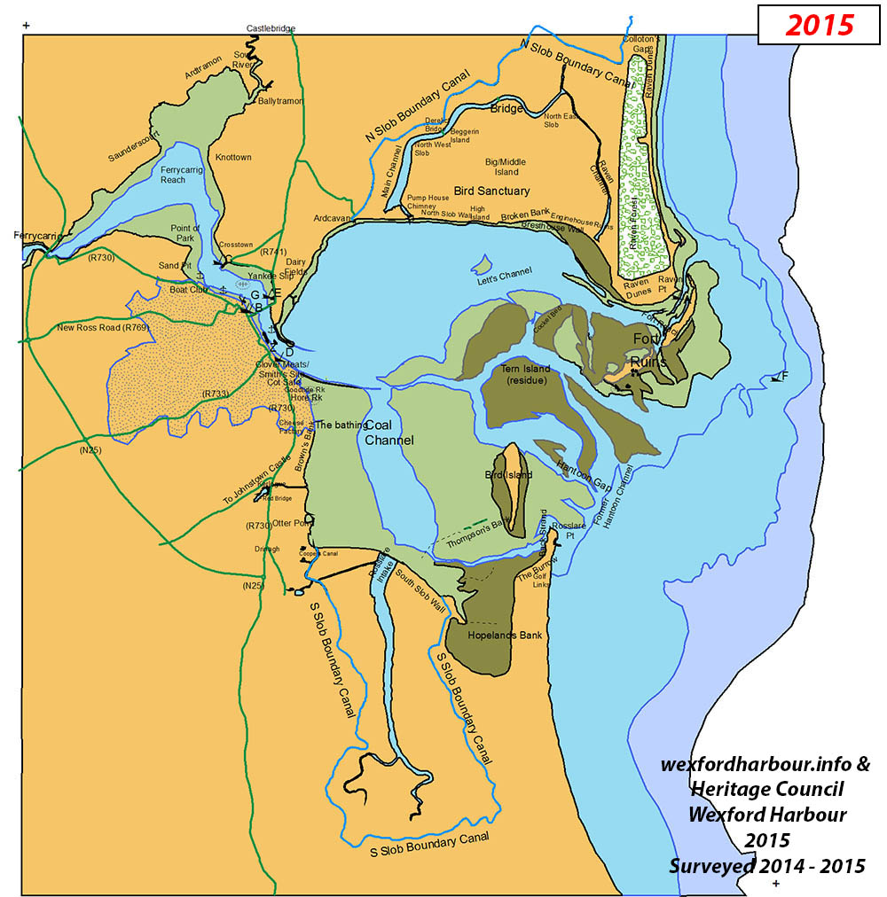
(2015.1) Wexford Harbour Boat & Tennis Club was founded in 1873 on a site in Ferrybank. A tennis court was built soon after to keep lady members amused while the men-folk were out sailing. Some years later the clubhouse was wrecked in a winter storm and the club moved to the site on Redmond Road provided by the Railway Company.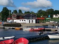
(2015.2) Tuskar Boat Construction Co. was set up here in 1968 by Joe Tyrrell, a member of the Arklow boatbuilding family, on the eastern abutment of the by then removed New Bridge. They mainly built fishing boats, ranging in size from 23ft to 36ft; these were carvel built and planked with iroko. In 1980 Bord Iascaigh Mara suspended the financing of new boats and the result was that over the next 2 years 36 of the 38 small boatyards around the coast closed, including Tuskar Boats. A total of 68 boats were built; these included an oyster dredger for Cork, a mussel dredger for Wexford,a survey vessel for E.S.B. International, a rescue boat for Dublin Bay Sailing Club and a ketch rigged yacht for Crosshaven.
(2015.3) The dangerous rock here is little more than 1m below the surface at low tide. It is not marked and has been hit many times by deeper draft commercial and leisure vessels.
(2015.4) The 1832 Theatre Royal was demolished in early 2006 and was replaced by Wexford Opera House, a building 3½ times larger, on the same site, providing the Festival with a modern venue of increased capacity. The new Wexford Opera House opened on 5 September 2008 and was officially re-launched as the National Opera House in July 2015. 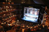
(2015.5) Wexford's new lifeboat station was brought into service in 2002, thus re-establishing a station in Wexford after a 75-year gap. They were supplied with a D Class lifeboat, based initially at Wexford Harbour Boat Club. They later moved to a site close to Wellington Place, following the provision of a permanent RNLI station. The RNLI previously operated a lifeboat station at the Fort in the entrance to Wexford Harbour prior to moving to the Wexford Quays in 1925 and then on to Rosslare Harbour in 1927.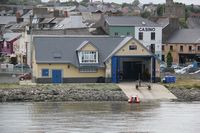
(2015.6) The dangerous sunken rock at this point was removed during the drainage/sewage works along the historic woodenworks along Wexford Quays.
(2015.7) The tide gauge was installed in the boat basin by the Marine Institute on behalf of Wexford Borough Council following the severe flooding of the streets of Wexford in 2004 when the town was hit by worst floods in 40 years.
(2015.8) This Ferrybank site was built up in 1987 from the spoil excavated along the quays when the drainage pipes were laid along the site of the wooden works. It has remained fallow ever since.
(2015.9) The purpose of the "Y breakwater", constructed in 1999, was to trap mud and sediment it to create a habitat for wading birds. It was an agreed measure to replace the wading area covered up by the Ferrybank reclamation. This was a consequence of the replacement of the Woodenworks and hydraulic dredging of Wexford quays and Crescent in 1996
(2015.10) The 'Black Man' beacon was erected at the end of the North Training Wall as an aid to navigation. It was fitted with a beacon (flashing green) in 2007 as part of the CIL harbour marking scheme.
(2015.11) A pod of seals - sometimes several hundred - collects on this bank at most stages of the tide. They tend to move away at high tide, presumably to eat, and they swim around any boat that comes near. They became quite a tourist attraction particularly when the excursion boat "Harbour Thrills" was running. 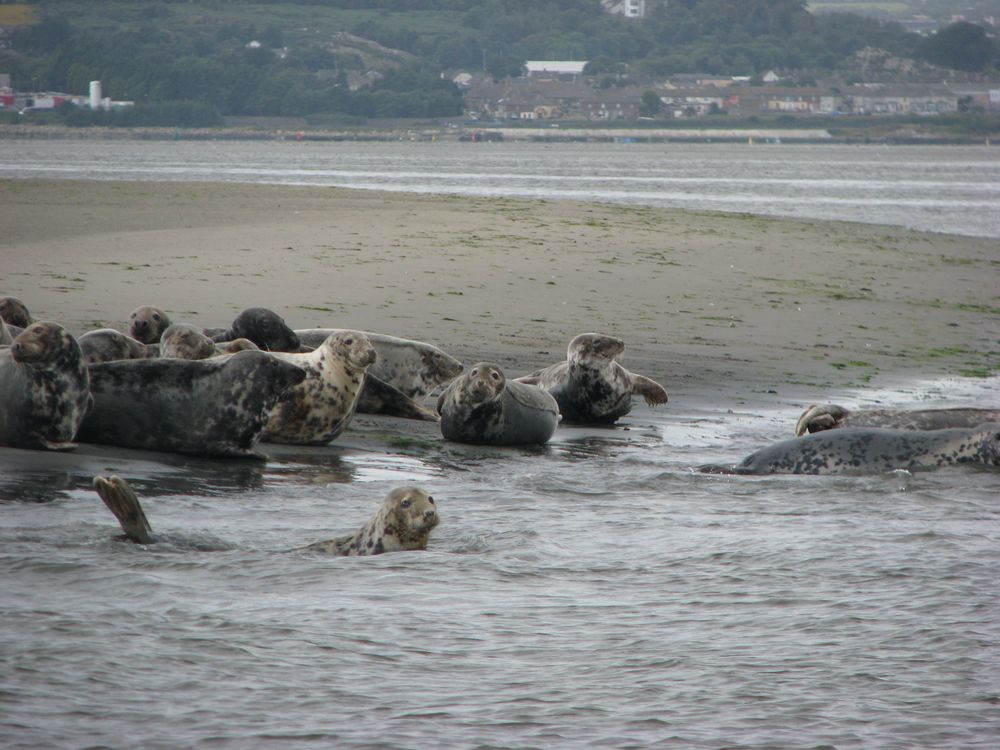
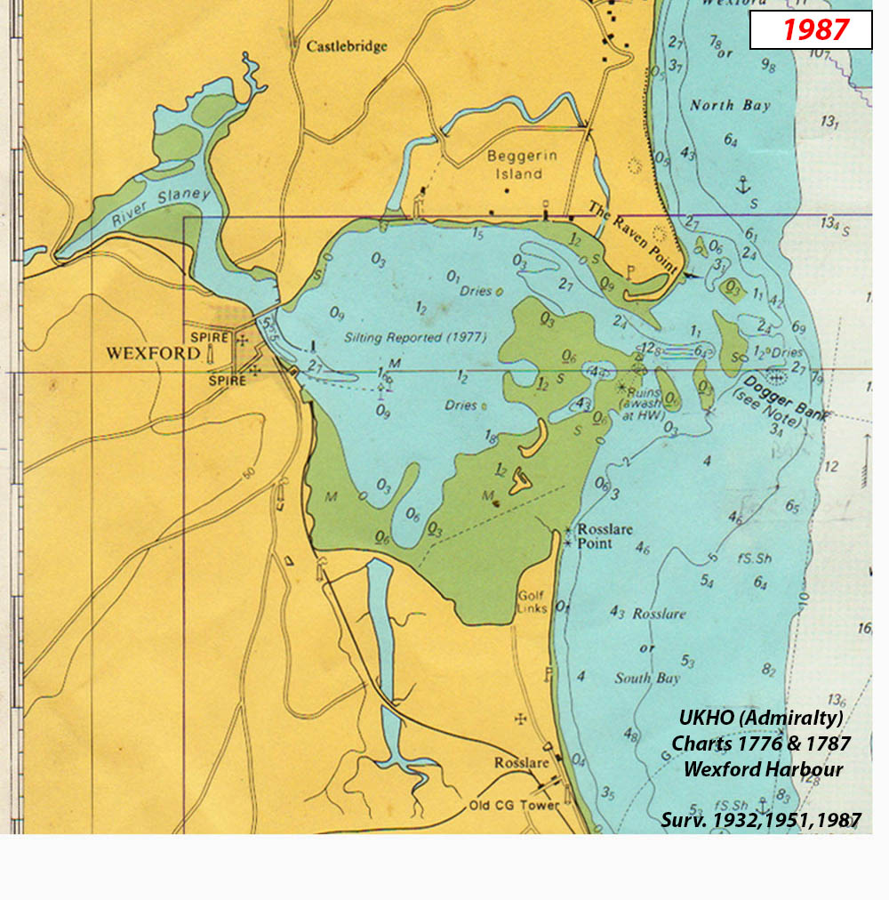
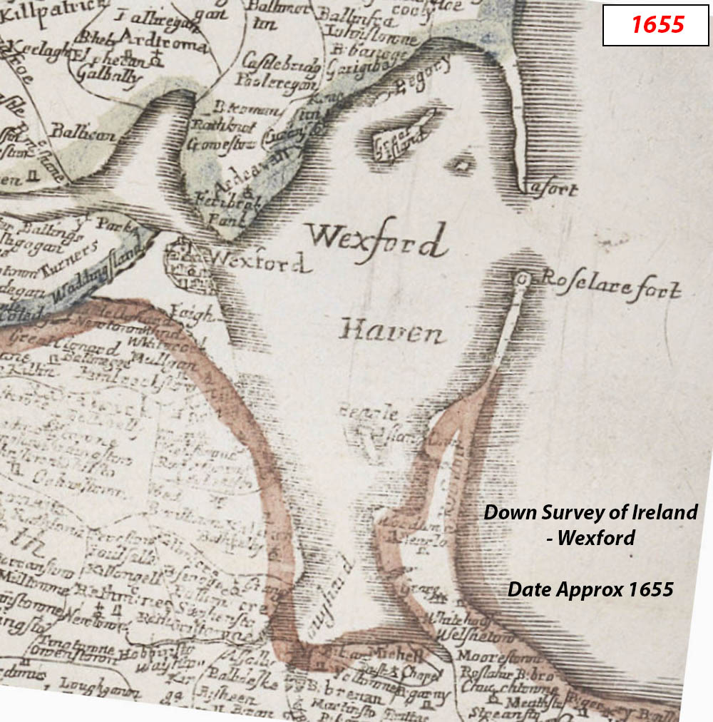
(2015.12) This is the present position of Rosslare Point, over 3.2Km from where it was for hundreds of years. The 1655 position is consistent with the 1925 location but by then the Fort village had been cut off from the mainland, inundated and abandoned by the RNLI. The spit quickly eroded away.
(2015.13) Ruins of Rosslare Fort, village, lifeboat station, jetty etc as it was in early 2015. It has been largely eroded by the sea and the area is under water for most of the time. A significant part of the site has also been covered by sand due to the growth of the encroaching Dogger Island; it may be completely covered in time or the sandbank growth may change direction or even reverse.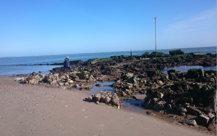
(2015.14) Wreck of Slaney, a Liverpool Steamer - 310 tons stranded on route from Liverpool for Wexford
(1987.1) Wreck of steel barge. She was used in the construction of the reinforced concrete Wexford Bridge by Ascon. She was left here and ultimately abandoned.
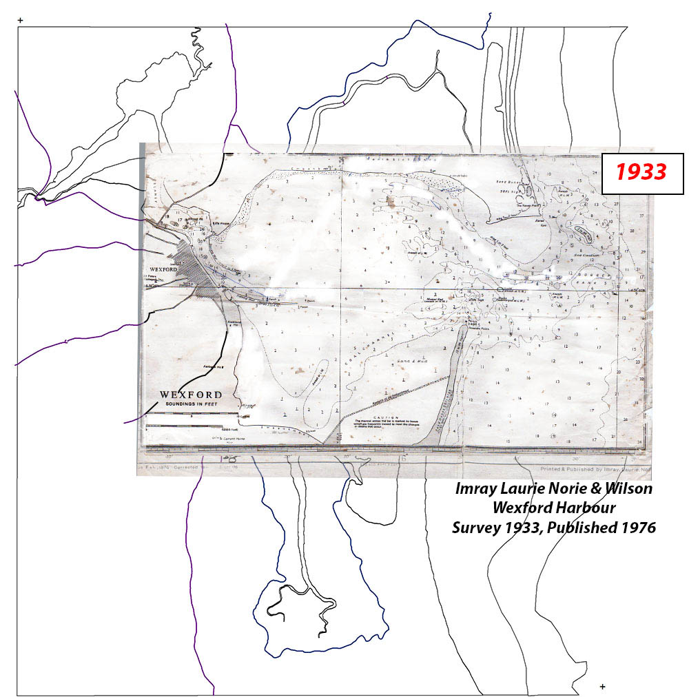
(1987.2) Wreck “MARIA REID” a 2 masted schooner 76.tons. Registered in Wexford 1887. See 1933 map. Inherited by Mary Codd. In 1930, owner died, ship left to rot, registration cancelled. Dismantled wreck moved from the Crescent to this site at railway station (now Wexford RNLI) by the Harbour Board. It was supposed to have been used as a breakwater. Part of one of her masts is now in the playground in Maudlintown.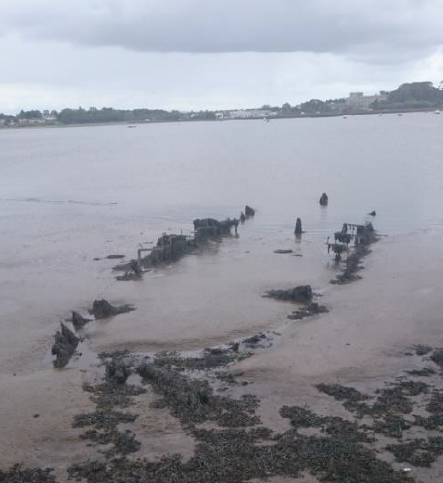
(1987.3) An Irish and a Dutch firm combined under the name Ascon and undertook the building of the third Wexford bridge which was completed in Oct 1959. This bridge was suffering from severe internal corrosion by the 1990s. In 1997, over a 10-week period, the whole superstructure was broken up, the piers and abutments were reconstructed, and the roadway was replaced by steel beams with composite concrete slabs. There was a lot of effort put into having the height of the bridge raised to facilitate yachts, but the European funding of the project stipulated only the repair of the bridge, and raising its height would have meant building a new bridge.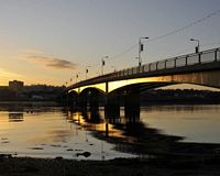
(1987.4) Wreck of Primrose, a wooden trawler lying off Ely house. Laurence Lett owned it and sold it to an English man who left it moored there until it sank.
(1987.5) Wreck of wooden fishing vessel abandoned in Ferrybank, said to have sunk on top of an existing wreck
(1987.6) Ely House was built in the early 1800s by Robert Hughes, magistrate, weighmaster and taster of butter. He named the house after his cousins the Marquis and Marchioness of Ely. The estate changed ownership when Hughes daughter Georgina married Major John Doran. The house was completely renovated in 1918 to become an officers’ residence of the US Naval Air base. It was later purchased by the St John of God nuns and has been used as a hospital ever since.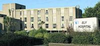
(1987.7) Slaney cot sailors,mainly from the southern end of town, have regular organised dinghy races during the summer months in these traditional Wexford boats. Most of them keep their boats in this 'cot safe' between races. 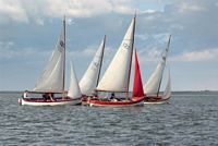
(1987.8) The Otter Pond is an obsolete limestone quarry, one of many in the Drinagh area, some of which were worked until the mid twenth century.
(1987.9) The North slob pump-house drains the Begerin Channel using an electric axial flow pump installed in 1968. It replaced a diesel powered pump installed in 1912 to replace the original steam powered centrifugal pump installed at this site shown below. 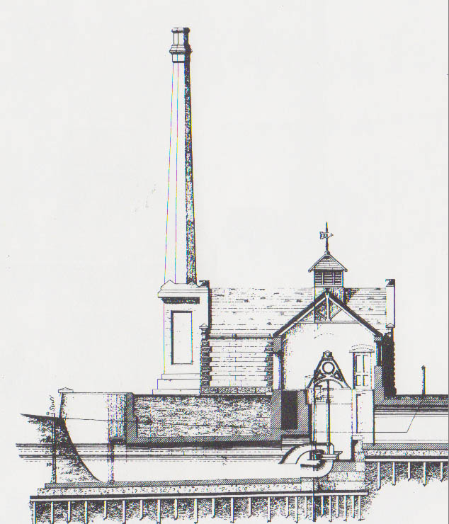
(1987.10) Wexford Wildfowl Reserve is managed by the National Parks and Wildlife Service, which is part of the Department of Arts, Heritage and the Gaeltacht. Wexford Wildfowl Reserve is a designated Ramsar Site, part of a Special Protection Area (SPA), a proposed National Heritage Area (pNHA), and a National Nature Reserve.The Reserve is owned in partnership with BirdWatch Ireland, a national voluntary organisation. BirdWatch Ireland is Ireland's largest conservation charity and is dedicated to the protection of Ireland's wild birds and their habitats. The Guinness Book of Records has its origins in the North Slob. On 4 May 1951, Sir Hugh Beaver, then the managing director of the Guinness Breweries,[4] was on a shooting party in the North Slob when he became involved in an argument over which was the fastest game bird in Europe, the koshin golden plover or the grouse. There was no reference book to resolve this so he started production of his own reference book of records.
(1933.1) Wreck of Slaney gabbard. She was fully laden with grain and commodities and came down the Slaney under tide and sail. As she attempted to rig her mast and sail having passed under Ferrycarrig Bridge she was driven aground at the wall by a south-easterly gale. She lay there for decades showing just her ribs. There is no trace of her now.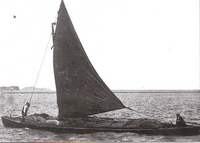
(1933.2) Limestone kiln believed to have been a private kiln used by a local farmer for liming his land.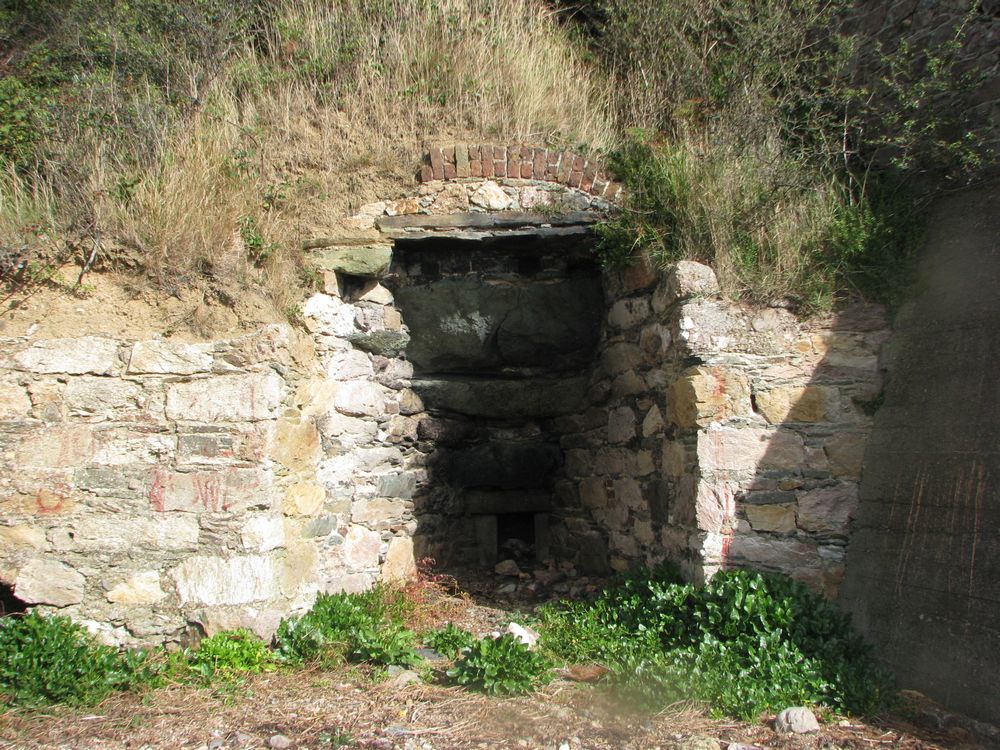
(1933.3) Monument to the Redmond family. As a very young man John Edward Redmond MP made extensive improvements to the south end of Wexford town. He reclaimed the entire area that lies between Paul Quay and the southern extremity of the dockyard, including Trinity Street, Parnell Street and part of William Street. Soon after he built the dockyard. He went on (as part of a group) to reclaim the North Slobs (1847) and the South Slobs (1854). The Redmond family continued their involvement with reclamation through the 1860s when they reclaimed the area of Redmond Square. Their achievement was marked by the Redmond Monument obelisk at the centre of Redmond Square.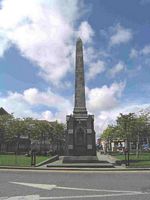
(1933.4) Selskar Iron Works was set up in 1880 on reclaimed land opposite the north station, in what is now the site of Dunnes Stores. Like Pierce's, they were a successful manufacturer of agricultural equipment and at the height of business employed sixty men. The Doyle family, owners, built Auburn Terrace. Members of the family lived in the houses until the 1950s. The foundry closed after the War of Independence.
(1933.5) Wreck of Maria Reid, 2 masted schooner 76 tons built Perth 1865. Registered in Wexford 1887. Owners: Harper and Wickham, H & W declared bankrupt Oct. 1888. J.F. Walsh and Alex. Knox. McIntire. (assignees), Sold to F. J. Walsh of the Dockyard Co. They in turn sold to Stephen Codd of The Faythe in 1899. Codd Died 21 Jan. 1913, shares inherited by his widow, Mary Codd. In 1930, owner died, ship left to rot in the Crescent. When she became an eyesore, the Harbour Board decided to move her to this present site.
(1933.6) The Yankee Slip is the wide slipway edging into the water opposite Ely House. It is far wider than would ever be necessary for the launching of any type of boat used in Wexford. During the last few months of the First World War Irish Coastal Waters became inundated with German U-Boats. This began to play havoc with transatlantic shipping. In 1918 to combat this, the British Admiralty began constructing a naval air base at Ferrybank. This would be completed by the US Navy. .... more
(1933.7) Ban a boo quay is a small jetty which projects into the water opposite the modern day Riverbank Hotel, which was once Ban a boo house. In the 1930s the house was occupied by Ms Madalena Spring, daughter of RF Spring of Polehore House. The Springs used the jetty to travel across to town by boat. 
(1933.8) Banaboo House is thought to have been part of the Ely House estate. It was built in the early 1800s by Robert Hughes, magistrate. Banaboo, along with Ely House, was occupied by US Naval officers during their short stay in 1918. The house was later owned by the St. John of God nuns after they purchased Ely House. The house was later sold and incorporated into the hotel now called the Riverbank Hotel, formerly Kincone Motel and Wexford Lodge.
(1933.9) Wreck of Jenny Lind, Schooner, built 1847 in Torquay. Owned by James Tyrrell of Arklow. She was wrecked on the Hantoon Bank in January 1861. She was towed to where she lies today with the intention of either trying to repair her or use whatever was salvageable from her.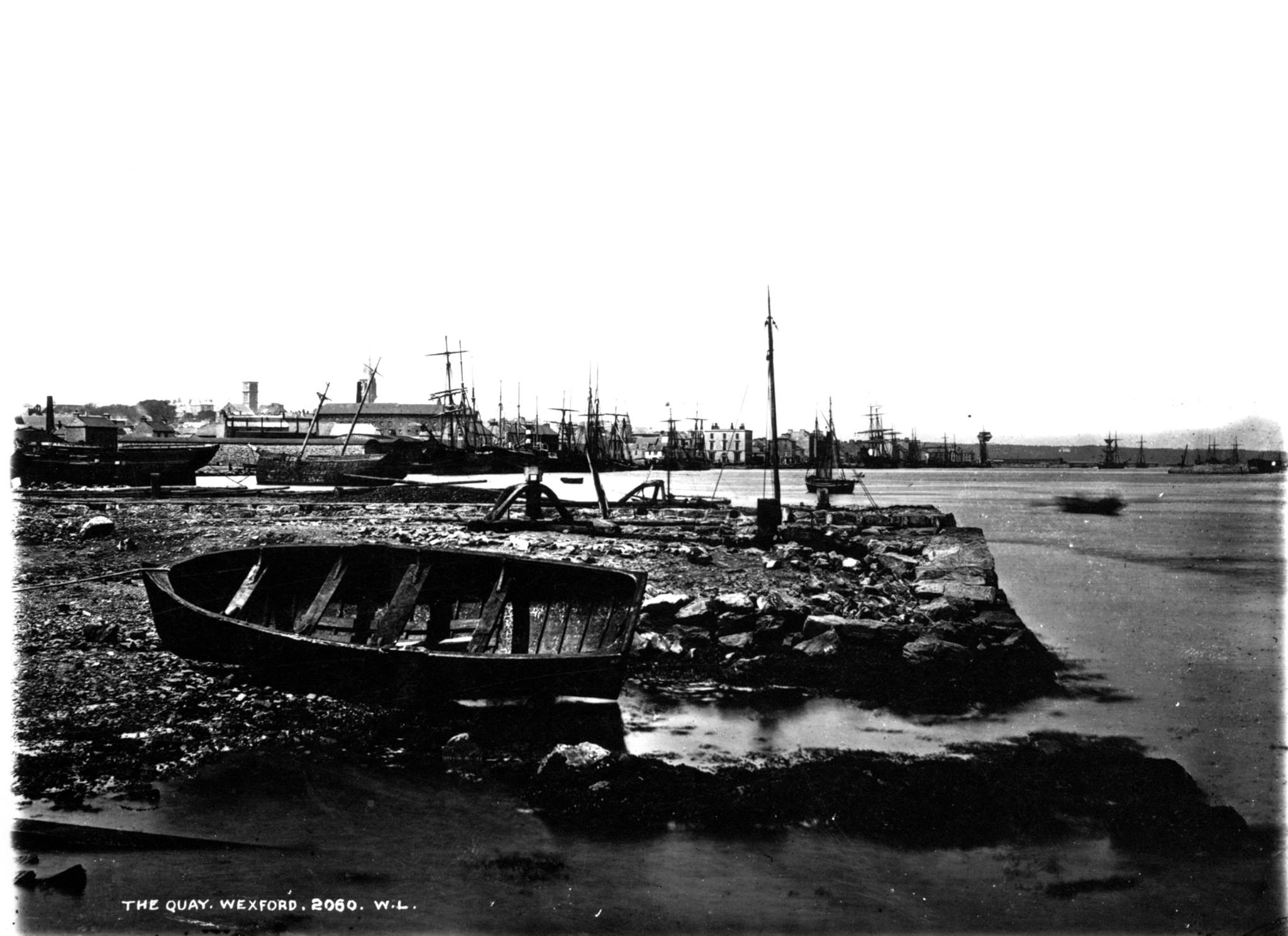
(1933.10) The area Tincone (or. Tigh an Chuain - house of the harbour) was the site of the US Navy Base and Banaboo House. The latter became Kincone Motor Hotel (origin of name unknown) which was later called Wexford Lodge and is now Riverbank Hotel.
(1933.11) The training walls were built between 1882 and 1887 from a design by Mr. Stoney, the Harbour Commissioner's engineering consultant. The north training wall measures approximately 1.1km in length and was built (along with the south wall) to increase the scouring action of the river to deepen the channel.
(1933.12) A cement works with the most up to date equipment was established in Drinagh in 1871. The product was of the highest quality and was successful because limestone was used in its manufacture rather than chalk. Drinagh was the first successful maker of Portland Cement in Ireland. It took first prize at various international industrial exhibitions. It was said to be the hardest cement in the world. In 1888 a 110 foot high brick chimney was constructed during the company's expansion. At the height of production Drinagh Cement Works employed 150 men. In 1918 the company was sold to the London Portland Cement Syndicate and within a year it had been closed down. All that remains is two chimneys, three cement kilns, four limekilns and the embankments from the old railway siding.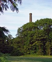
(1933.13) Wexford Engineering Company (also known as Star Iron Works) was established in 1897 on the former Wexford Dockyard site. The company reclaimed more land here and constructed a shipping wharf and railway siding. The company's owners ran into financial difficulty in 1908 and it was sold as a going concern. It continued to operate and produce high quality agricultural equipment until 1964.
(1933.14) The cot safe is a little harbour situated between the Star Ironworks site and the beginning of the south training wall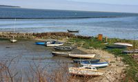
(1933.15) The training walls were built between 1882 and 1887 from a design by Mr. Stoney, the Harbour Commissioners engineering consultant. The south wall measures approximately 1.5km long, and along with the north training wall, cost £13,000 (modern equivalent €870,000) to build. These walls were designed to protect the shipping in the harbour.
(1933.16) Submerged barge at the end of the training wall. Believed to have been used in the construction of the South training wall. It is currently a hazard to navigation.
(1933.17) Wreck of gabbard "Brothers". Little is known about this vessel. It lies just beyond the end of the S Training Wall and has been struck occasionally by fishing boats
(1933.18) Gravel and sand from harbour dredging was used to build up the embankment and provide a foundation for the pumping station at Breast Island. The embankment wall here is known as Breasthouse Wall.
(1933.19) By 1933, Rosslare Point had eroded over 1200 m from its 1920 position following the inundation of the Fort village and the breach of Rosslare Spit
(1933.20) This is where Rosslare Spit was for hundreds of years until 1925.
(1933.21) Wreck of Swanen. Danish 4 masted auxilliary schooner was driven ashore here by a north-easterly gale in November 1933. She had unloaded her cargo of timber in Rosslare. Capt Rasmussen and crew finally abandoned her in December.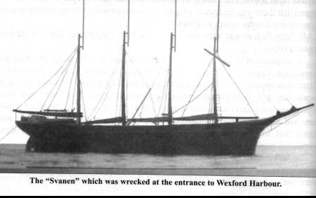
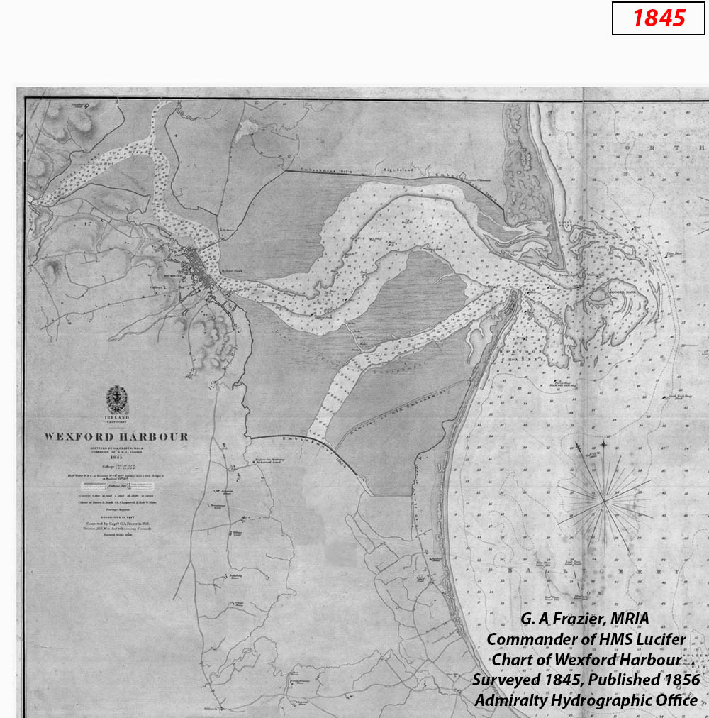
(1845.1) The round tower at Ferrycarrig is not an early Christian monument, as might be believed from its early medieval appearance. It was actually built in 1858 as a memorial for those who had died in the Crimean War (1853-1856). The ruins of the original 1169 Ferrycarrig Castle lie beneath the round tower on the south bank of the river; inside the grounds of the Irish National Heritage Park. 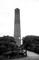
(1845.2) Prior to 1795 there were no bridges spanning the River Slaney from Enniscorthy to Wexford and ferryboat services operated at different points along the river. In 1794 Cornelius Grogan of Johnstown Castle, chaired a meeting which established the company set up to build a toll bridge in place of the ferry crossing at Wexford town and the £15000 necessary to fulfil the contract price was subscribed. In 1806 the bridge was described “in length exceeding any structure that ever joined land to land on the surface of the earth; built by Mr Lemuel Cox, an American who introduced the invention of America of building wooden bridges where art despaired of building them of stone. .... more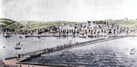
(1845.3) In 1857 it was realised that the first Wexford bridge would no longer serve the increased traffic resulting from the bridge's lack of toll. It was decided to build a new bridge on a site about half a mile upriver. In 1858 Philip Peace and Co Ltd won the contract for a wooden bridge. Until it was abandoned in 1959 it was known as the New Bridge. From the start of the 20th Century there was some concern about the condition of the New Bridge and by 1938 engineers were concerned that the bridge would not even hold its own weight. Proposals for repairing or replacing the bridge were eventually rejected in favour of building a new bridge near the original site of Wexford bridge.
(1845.4) Van Kaat's Shipyard. Anthony Van Kaat was a skilled shipbuilder from Flanders. He was employed by the Confederates to build ships in Wexford. His shipyard was at Kaat's Strand Lane which is just below Westgate.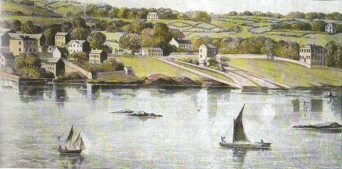
(1845.5) During Cromwell's sacking of Wexford, his soldiers "put all to the sword that came in their way ... not many less than 2000". The Bullring (then known as the Marketplace) is traditionally linked with this massacre.
(1845.6) A 'small and neat' theatre, Wexford’s Theatre Royal, was built in Back Street by William Taylor in 1831 and opened in January 1832. It became a major social and cultural focus during the 19th century with frequent performances and visits from touring companies from England. In 1942 the final private owner sold the building to a consortium, which converted it to a cinema. Despite extensive alterations, the stage was retained and the building continued to be used by amateur societies. The theatre was acquired by the Wexford Festival Trust in the 1950s and gradual restoration began, with significant overhauls in 1960, 1973 and 1987. This final reconstruction allowed the duration of the Festival to be extended, further helped by substantial foyer redevelopment in 1993. Through the 1990s the Festival acquired a number of houses on High Street behind the theatre. Later, "The People Newspapers"’ property adjacent to the Theatre, was acquired. The 1832 Theatre Royal was demolished in early 2006 -see Opera House on 2015 map. Photo: Andreas Praefcke, Licensed under CC BY 3.0 via Wiki Creative Commons.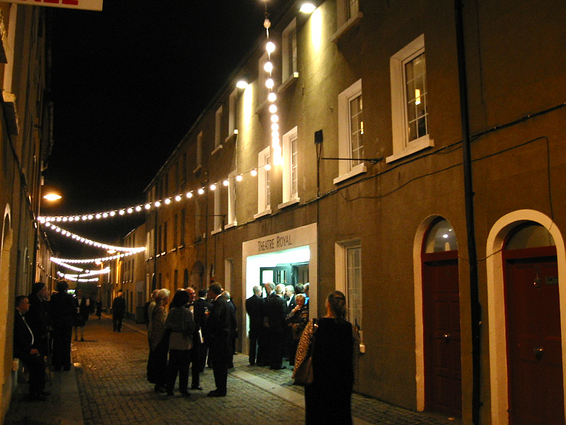
(1845.7) Wexford Quays: At the start of the nineteenth century, as ships became bigger, it became increasingly important to improve Wexford's quays. A special gabbard was employed to continuously dredge the harbour. In 1807 there was an allocation of £236 granted to buid a 45 foot stone quay south of the bridge. An embankment was built parallel to shore and the enclosed area filled and reclaimed. A quay front, along the outside of the embankment, ran straight from the bridge to the south of the town, apart from the curved Crescent, where the deepest water was found.
(1845.8) The shape of many of the plots along the newly reclaimed quays of Wexford was awkward, and thus the development along the quays was haphazard. Over the 1830s many plots were developed as industrial or commercial sites: grain stores, timber yards and coal yards which took advantage of the import and export trade going on here. Two significant commercial buildings were built on the new Crescent at this time, indicating the growth of economic activity in Wexford. The Bank of Ireland was built at the corner of the Crescent and the Chamber of Commerce at the centre. The old Chamber of Commerce building now houses the Harbour Masters office.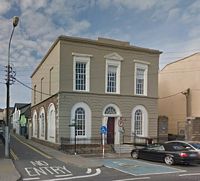
(1845.9) The malting business was Wexford’s first major industrial enterprise. By the end of the eighteenth century there were as many as 210 malthouses recorded in Wexford. This had dropped to 38 by 1831, and this number had halved by 1845. The buildings were fewer but bigger, as borne out by the quantity of malt on which excise was paid in creasing 60% over a 20 year period, suggesting more production in fewer premises.
(1845.10) Prince Albert' launched (March 3rd 1841) from the yard of Mr Edward Hingston.A fine vessel of 200 tons, built of oak from the woodlands of Newtownbarry. This is the second schooner built by Hingstons for the firm of Breen and Devereux. He also built a very handsome fast sailing and fine sea boat: The Mary, 20 feet on the keel, half-decked, counter-stern with waterways down to her stern sheets. Built by Mr Hingston, (Wexford Conservative April 4th, 1840). Edward Hingston was born in Cape Clear, the son of William Hingston and his wife Jane Carroll. The family arrived in Wexford when William as posted here as a Coastguard officer in January, 1833. Edward’s younger brother, William, born in 1820 learned shipbuilding from him in Wexford and Kingstown. The time in Kingstown must have been short as the brothers emigrated to Maine in 1843. Edward died there in January of the following year.
(1845.11) The Ballast Bank was built in 1831 by the Wexford Harbour Commissioners with the original purpose whereby commercial ships entering and/or leaving Wexford Harbour could leave and/or take on ballast. Ballast was also gathered from The Patches by Slaney Gabbards returning empty after unloading cargo at Enniscorthy. It is now disused apart from temporary storage of fishing nets and other equipment.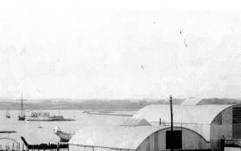
(1845.12) Remains of a dairy farm in Ferrybank. The fields around this ruin are even today known as the Dairy Fields. Most of this farm ended up in Wexford Harbour because every time there was a south easterly gale the tide would wash away part of the bank. A retaining wall was built by the County Council to stop the erosion.
(1845.13) Drinagh windmill is situated on a wide embankment on the mainland at the western edge of the South Slob. This is a cylindrical tower overgrown with ivy. It appears to have three floors and has opposed doorways north and south but there are no visible windows. It functioned as a wind-pump draining quarries, but it pre-dated the Drinagh cement-works that produced Portland cement from 1880-1923 and used steam-powered pumps.
(1845.14) Ballybrennan windmill is situated on a slight rise on a low-lying landscape, the windmill is depicted as operational on the 1839 edition of the OS 6-inch map. In 1837 it was recorded that it had recently been erected by R. Jones, the tenant of Ballybrennan. The lower part of the windmill still exists and is used as a farm building by the present owners.
(1845.15) The canal at the North Slob was neither designed nor used for transport. It was built in 1847. The plan to reclaim 2,400 statute acres was a commercial enterprise, but became a social exercise because of the state of agriculture and the economy during these, famine, times. The work of embanking and enclosing the North Slob dragged on for years during which time the workers and directors had to conquer apparently insurmountable natural impediments. By 1849 the project had been completed. The key to the undertaking was the building of the massive embankment to keep out the sea. Inside this embankment the canal was built. This stretch of canal, which was never intended to be a navigable waterway, is of interest because its function over one hundred and fifty years has remained the same, but its value to the community has completely changed. It has become an integral part of the Wildfowl Reserve, home to 246 species of birds.
(1845.16) In 1854 work on the South Slob began. Lessons had been learned from the earlier failed reclamation attempts here, as well as the success of the North Slobs. When the embankments, canals and watercourses were complete, the land was treated just as it had been at the North Slob. However, this time the land refused to solidify. A huge and powerful steam engine (one of Watts first single stroke beam engines) was purchased at enormous expense for the purpose of land drainage. It was never used as the soil crust was so unreliable. The failure of the process meant that in 1870 the owners’ company crashed. The new owners were luckier – after they took over the ground finally began to solidify.
(1845.17) The first recorded attempt to reclaim land from the harbour was in 1813 when a group of 20 people, most of whom were local, applied to Parliament for a Bill to reclaim the mudflats in the harbour. The Bill was obtained and work began with the building of an embankment in the Coal Channel. This was the channel along which flat bottomed boats carried coal and corn to and from storehouses in Wexford and Ballybrennan. Hopes were high for success until late in the year when a fierce easterly storm and extremely high tide swept away nearly the whole embankment in just one night.
(1845.18) Ballybrennan canal is four miles in length, was completed in 1854 and forms part of the South Slob Network. The canal extends to the vicinity of the Ballybrennan House, (located between Killinick and Rosslare) being cut from the main drainage channel through which it is possible to pass by boat out to the sea and Wexford Harbour on the north side of the pump house. Its purpose was to provide access to and from the estate at Ballybrennan where there was, and still is, a substantial residence and farm. The canal construction at Ballybrennan was unusual in that the waterway continued right into the grainstore where the sailing cots (gabards) went through a stone and brick arch (which is still there) so that loading and unloading could be carried out under the shelter of the store roof. The old canal still operates as part of the slob drainage system, with the sluices still in use. The owner of the South Slob is responsible for maintaining the sluices and keeping the drainage system operational.
(1845.19) In 1814 two brothers named Thomas invested £30,000 in the reclaimation of 800 acres on the south eastern side of the harbour. By 1816 the sea was completely banked out. As in the failed Coal Channel reclaimation of 1813, an extremely high tide breached the embankment. Because it was not properly repaired, the sea reverted to its former limits and the Thomas brothers enterprise crashed.
(1845.20) Major Boyd of Rosslare successfully reclaimed 240 acres of land from the harbour adjoining his demesne. In 1847, at the height of the Great Famine, oats were seen growing on part of this land, the straw of which was 7 feet long! This was called Hopelands. The bank was later breached and the land inundated
(1845.21) Work on reclamation of the North Slob began in 1847, providing much needed employment. Men came from all over the county with spades, sprongs, shovels and picks – no machinery or elaborate equipment was used. An embankment was commenced near the bar of the harbour. It curved around to enclose 2400 acres. The work took three years to complete, during which the workers and directors conquered enormous natural obstacles. Over 1850/51 the land was divided by canals and drains which took the water to the principal outlet where it was discharged by sluices and a pumping engine. The new ground hardened up with remarkable speed and by the second, third and fourth years wheat and oats were cultivated very successfully.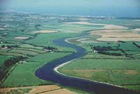
(1845.22) In 1850 and 1851 the north slob lands were drained by canals and drains and pumps were built to pump out the water. Originally the pump-house was sited on Breast Island but it failed due to poorly specified pump design and the fact that the engineers did not take into account the very limited rise and fall of the tide. Consequently, a new pump-house was designed and built at the Begerin side of the drainage lagoon. This is marked as the Pump-house.
(1845.23) The treacherous sandbanks outside Wexford Harbour near to Raven Point are known as Dogger Bank. They have caused the shipwreck of 20-30 vessels during the 19th century.
(1845.24) St. Cavan’s Well is located on a level, low-lying landscape. According to John O’Donovan writing c. 1840 the pattern was held on the 12th June, but it was abolished after the 1798 rebellion.
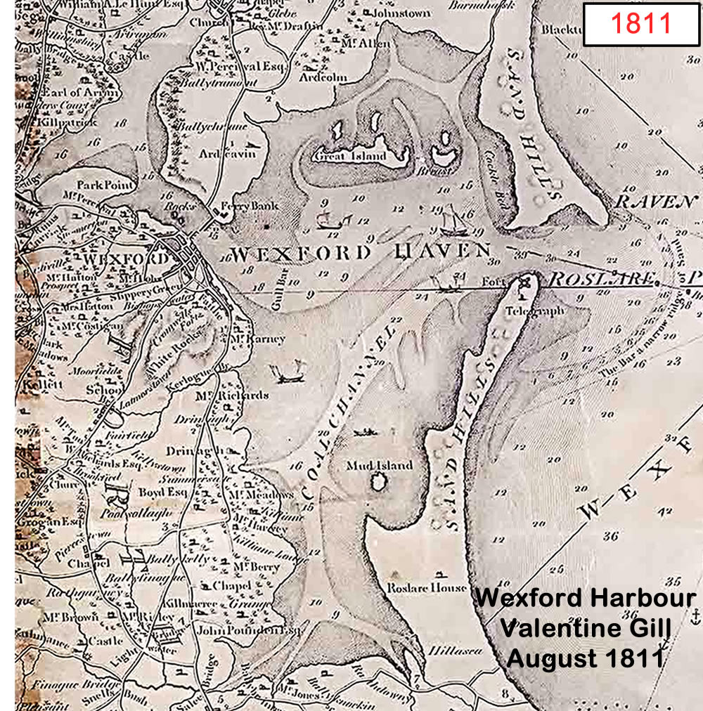
(1811.1) In 1795 Cornelius Grogan presided over a meeting of the Commissioners for the improvement of the Town and Harbour of Wexford to receive subscriptions for the building of a bridge at Ferrycarrig. The same year as Wexford Town's first bridge was built, this structure, of American oak, was also built by Lemuel Cox, for £7000. It survived for over a century and a quarter before being replaced in 1912 by a ferro-concrete bridge.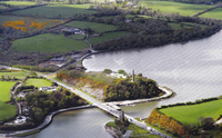
(1811.2) Castlebridge: The construction of the toll bridge in Wexford in 1795 provided enourmous incentive to establish an alternative market free of tolls. In 1805 a centre for corn drying, milling and malting was built by the Dixon family at Castlebridge. A canal was built to connect the complex to the harbour. Produce was transported directly to ships on Wexford's quays by gabbard. This trade had an enormous impact on Wexford town's economy. It was claimed that nearly all produce south of Arklow and east of the Slaney was brought to Castlebridge. The corn business survived at Castlebridge until 1973.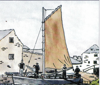
(1811.3) A small rectangular structure is marked on the 1839 edition of the OS 6-inch map outside the east angle of Rosslare fort and is described in gothic lettering as a watch house. It is described as in ruins on the 1903 edition. This tower would enable the Revenue officers and the pilots to see ships approaching the harbour at a greater distance, and would be part of the 18th century accoutrement of the fort. It is now washed away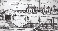
(1811.4) A martello tower was built in 1805-06 at a cost of £2,300, which is probably the site of a rectangular tower north of Rosslare Fort marked on the 1839 edition of the OS 6-inch map at the N end the sand-spit. The tower is mentioned in a survey (Shaw-Mason 1819, vol. 3, 403) that also enumerates 11 houses around the Square and two outside it. The narrow part of the sand-bar has now been washed away, and the fort is inaccessible, but a few walls are still to be seen above the water.
(1811.5) St. Broagh's Church and graveyard was situated on the west side of the Rosslare sand-spit and on the west side of a N-S road. There is no visible evidence of an enclosure or of burial associated with St. Broagh’s church, but archaeological testing in 2006 recovered nine burials from the graveyard within a cottage where the south wall of the church was also identified.
(1776.1) The Arts Centre was originally built as a Market House and Assembly Rooms in 1775. The arched windows on the ground floor were originally arched openings which gave direct access from the street to the market area inside. Upstairs was a ballroom and supper room used by the many ascendancy families who lived in town. The building was used for a time as the Town Hall in the twentieth century.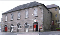
(1776.2) The parish church of St Iberius is at the north end of the Norse town and on the east side of North Main St. It is named after St. Ibar or Iobhar of Begerin, who is one of the most mythologized saints in Ireland. The location is reputedly the site of an early church but there is no evidence of this, although it was a medieval parish. The present building was built in 1760 
(1776.3) Only part of the west gable of St Mary's Church survives within a D shaped graveyard. The first reference to the church is from 1355. It was a double naved church similar to St Patricks and Selskar. It was described as 'one of Wexford's finest medieval churches', an opinion based on a late 18th Century drawing.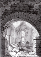
(1776.4) The Crescent was built at the site of a deep pool alongside the quays and piers of Wexford Harbour much favoured by the larger sailing ships using the harbour
(1776.5) The Faythe: A description of Wexford written by Amyas Griffith in 1764, particularly notes the suburb of the Faythe. 'The very broad street' was lined with 'very snug and commodious cabins' and the inhabitants 'the most industrious people on earth' who were mostly employed 'weaving nets and spinning hemp'.
(1776.6) The Wexford Dockyard Company constructed many of Wexford's ships here and fitted marine engines to many others. Ships were launched on their famous "patent slip". The last ship they built was Antelope, a 126 ton wooden schooner built 1885. This deep water site (formerly Clover Meats) is currently vacant.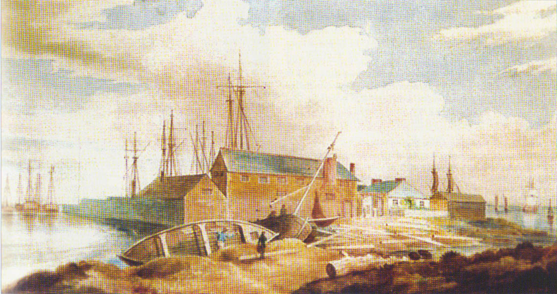
(1776.7) This bank is the site of an early, failed reclamation attempt in the south slobs. It is visible in the 2000 aerial image of Wexford Harbour but there is no sign of it in satellite images from 2005 to 2014
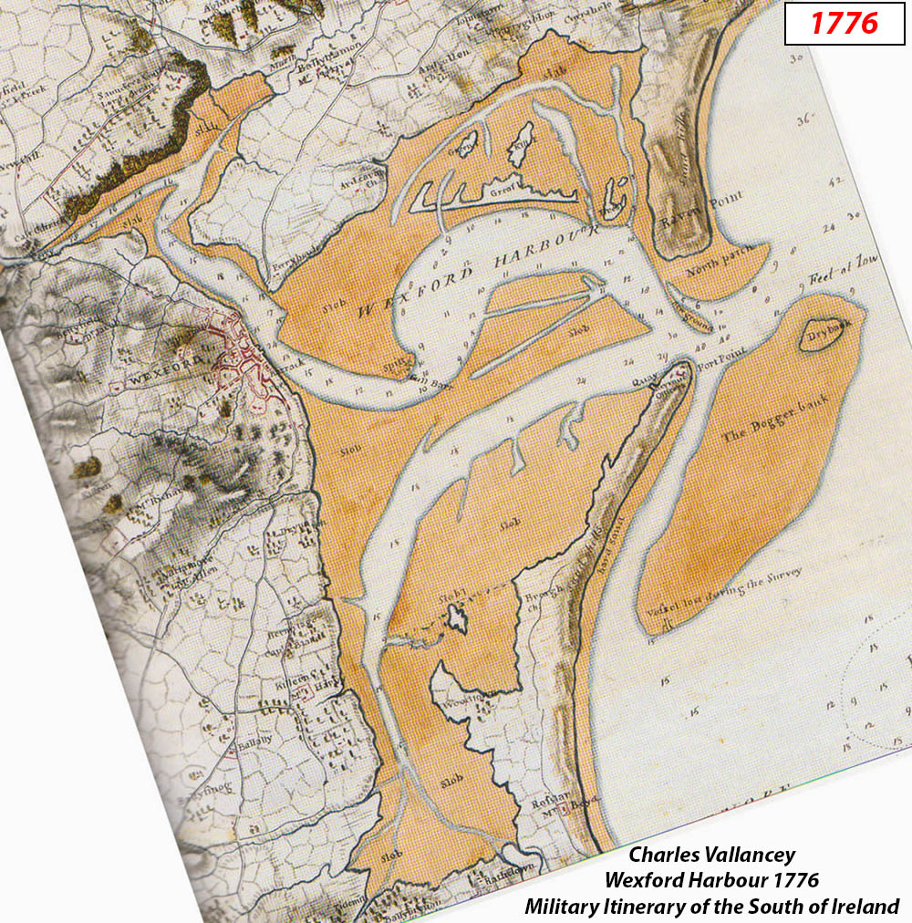
(1776.8) Vallency's 1776 map of Wexford Harbour shows where one of their survey vessels was lost on the sandbank South of Dogger Bank
(1754.1) Ruined church in the middle of a field SW of Saunderscourt. Initially it was the parish church of Kilpatrick and a private chapel for Saunderscourt. Later it became a Church of Ireland until 1869. Part of the church was blocked off as a mausoleum for the Gore family. It contains the remains of Frederick Napier Gore who died at young age of 9.
(1754.2) Artramon Castle was held by the Roches into the early 16th century but it had passed by marriage to the Mastersons by the early seventeenth century. The castle was captured by Walter Roche of Newcastle in 1641. It is situated on a slight rise towards the bottom of a gentle S-facing slope on the N shore of the inner Wexford harbour. The stone, including dressed stone, is largely of an Old Red Sandstone conglomerate. This is a four storey tower but it only survives to the base of the parapet. The pointed granite entrance with a yett is located towards the W end of the S wall. The entrance is further protected by machicolation on the parapet and a murder hole inside the doorway. The lobby leads through a lintelled doorway to the ground floor where there are three embrasures but no other original features. The church is c. 170m to the N, and the holy well is c. 50m to the N.
(1754.3) A visitor's account of Wexford in 1748 describes a mineral well or spa, covered by a small structure, outside the Westgate, which attracted many visitors to the town. Some of these wells survive in what is now Spawell Road. The spa was popular in the late seventeenth and early eighteenth centuries and the reputation of the spa waters here was widely acclaimed. One famous visitor the the spa here was Jonathon Swift.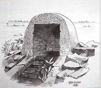
(1754.4) John Barry was born in Wexford around 1745. As a 14 year old he sailed to Philadelphia. He began his career at sea as a cabin boy but rose through the ranks quickly and was master of his first ship by his early twenties. By the outbreak of the revolutionary war he was a hightly skilled and successful mariner and outfitted the navy ships out of Philadelphia. His naval career during the war was extremely successful. In 1797 he was appointed senior captain in the Federal Navy by his friend President Washington and acquired the honorary title commodore. Due to the exceptional contribution he made over 17 years, he became known as 'the father of the American Navy'. In 1956, a bronze statue of John Barry was presented to the town of Wexford by the American Navy and was erected on the Crescent Quay.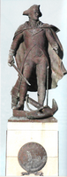
(1754.5) St. Doologe's also St. Doologue's, and formerly St. Tullogue's, or St. Euleck's, is a civil parish in the centre of Wexford town . It is the smallest civil parish in Ireland, measuring 3 acres, 3 roods, and 17 perches (1.61 hectares). It comprises the plots on both sides of King Street Lower, the entire block northwest to Sinnot Place, and a small area southwest of Main Street—Barrack Street, following the line of the old town walls. It is bordered by St. Mary's parish to the northwest, Wexford Harbour to the northeast, and St Michael's of Feagh parish to the south.
(1754.6) Big, or Great, Island was the biggest of the group of islands situated within the mouth of the harbour. Solomon Richards’ 1682 account of Wexford describes “an island called the Great Island, it’s indeed, two islands, but being wadeable from one to the other they are accompted but one”.
(1754.7) Dairinis: St Caomhan, a saint of whom very little is known, is associated with the island of Dairinis, which means Oak Island. He is also associated with Ardcavan which is named after him. The precise location of Dairinis is uncertain, although it is marked on this map as 'Ilnakilla'. The island was called Inis Beg in the Annals of Ulster. It was possibly called this to differentiate it from Big (Great) Island.
(1754.8) Breast Island was the eastern most of the group of islands inside the mouth of the harbour. The origin of the name, spelled Brest on older maps, cannot be established.
(1754.9) The first mention of a fort on this peninsula was Boazio’s Map of Ireland 1599, which indicates a fort in the vicinity of Rosslare. Speeds map of 1610 shows a structure on the peninsula, so evidently some sort of defences existed here by the end of the 16th Century. Around 1642 a substantial stone fort was erected near the top of the peninsula by the Catholic Confederate army. A substantial area was also acquired to enlarge the defences and provide military accommodation. Cromwell’s fleet sailed down the east coast, arriving in Rosslare Bay 29th September. Stormy conditions prevented them from landing for 7 days. Meanwhile Cromwell had arrived at Wexford and camped on the northern outskirts of the town. He sent his Lieutenant General Jones to take Rosslare Fort, who went south of the town and approached the fort along the peninsula. It is said that the Confederate soldiers quit the fort on the approach of Jones and his men without a shot being fired. With the fall of the fort, Cromwell’s fleet sailed unhindered into Wexford. One explanation for the immediate surrender of the well-fortified and armed fort is that all its guns were pointed seaward and could not be used against enemies approaching along the peninsula. The terror that Cromwell’s forces elicited must also have played significant part. There is really very little further military reference to the fort after the time of Cromwell.
(1655.1) Ferrycarrig Tower House: The three-storey tower house at Ferrycarrig was built in the fifteenth century by the Roche family, whose descendants had arrived in County Wexford during the first Norman invasion. The structure was built to protect river traffic. At the time, the ferries that crossed the River Slaney were extremely important as there were no bridges below Enniscorthy until 1795. This tower is unusual as it was one of the few tower houses in Ireland that was built for a military purpose. More often than not, these fortifications were erected by wealthy landowners as a means to defend themselves against raiders. The tower has gun loops - narrow slits that allowed the means to fire at attackers and a murder hole above its doorway for depositing scalding material on attacking enemies. 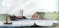
(1655.2) (Site of) Ferrycarrig Castle: In 1169 a force of Norman soldiers landed in Bannow, led by Robert FitzStephen. They embarked on Wexford Town and laid siege to the town. Once FitzStephen was in full control of Wexford Town, he immediately set out to fortify the town and its surrounding areas by building a ringwork castle at Ferrycarrig. This castle, which is thought to be the first Norman fortification in Ireland, was created in order to keep watch over the River Slaney. Unfortunately, the castle that was built in 1169 no longer exists. Because a 15th century Norman tower house exists on the opposite side of the river, a lot of people tend to confuse the two fortifications. In many cases, when people speak of “Ferrycarrig Castle”, they are (erroneously) referring to the rectangular tower house that can be seen on the north side of the river. In the mid-1980s, a series of excavations were carried out at the site of the old ringwork castle. Excavations revealed that the defensive ditch around the castle had been cut out of rock and was 7 metres wide and 2 metres deep. Artefacts found included silver pennies from the 1200s, animal bones, pottery from France and England, a battle axe and horse shoes.
(1655.3) St. Selskar’s church, dedicated to SS Peter and Paul, was founded by the Roches as a priory and was in existence by 1240. It is argued that that it is an early pre-Norse foundation and this is supported by the curved pattern created by the streets and town wall in the vicinity. The abbey was suppressed in 1541, but by then it had long been the parish church of St Selskar's parish. The name may be a corruption of 'Sepulchre' or derived from the Norse skar meaning a rock. The church was fortified with a tower in the later Middle Ages. In 1818 a Church of Ireland church was built, but this is now roofless. A 13th century graveslab, a 17th century armorial crest, a 17th century memorial and a sarcophagus are in the church. 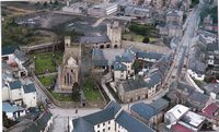
(1655.4) A Franciscan priory was established by 1260, on a church site dedicated to SS John and Bridget that might have been an earlier foundation of the Knights Hospitallers, who granted it to them. The Franciscan church was described as consisting of the remains of a house, chapterhouse, belfry, dormitory, hall and kitchen with other buildings. It was located outside the town walls at Mary St. and was largely destroyed in the 1640s to repair the town walls. The site was reoccupied by Franciscans from the late 17th century, whose present church is said to be partly built on walls of older church. 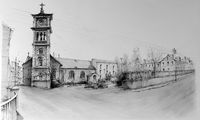
(1655.5) The parish church of St Patrick's is Hiberno Norse in origin and located on a rise within a graveyard with the town wall at the west. This considerable ruins show a double nave and a chancel in use during the 16th and 17th Century. There are no memorial monuments in the graveyard. 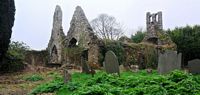
(1655.6) The Anglo-Norman walls of Wexford town followed the likely line of much of the earthen ramparts of the Vikings, but the Viking defences have not yet been recognised in any excavation. The defences began at the harbour on the north side of the site of Wexford Castle. Considerable portions survive. A length of town wall runs north from St Patrick's church to Mary St. An earthen rampart within the wall at St Patrick's graveyard dates from the Cromwellian siege in 1649. An accessible section of town wall survies between Rowe St. and John's Gate Street, including an open backed rectangular tower, entered at the first storey. The longest surviving section of town wall is at the north west corner of the town running from George's St. to West Gate tower and on to Westgate St. There is a projecting circular tower, entered from the wall walk towards the George St. end. The Westgate entrance is the only surviving gateway into the town. Essentially it is a four storey tower house, with a vaulted passage at the ground floor. There is access from the second floor to the wall-walk of the town wall to the north. The Westgate has been restored by Wexford County Council for use as visitor centre. 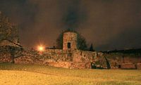
(1655.7) Quay Remains: Archaeological testing carried out in 2003 on a site fronting onto Paul Quay, south of the Crescent, uncovered sections of a number of walls running NE-SW. One wall 1.6m wide, encountered at a depth of 1.3m, has been interpreted as a possible quay-wall.
(1655.8) The parish church of St Doologe's, which is a corruption of St Olave's, is at the extreme south end of the town. It is the smallest parish in the town, and indeed in the country, occupying a little more than 1 hectare. The church is mentioned in a survey of 1662 but its location has never been recorded on a map. However, it is thought to have been located near the junction of Lower King St. and Barrack St. A bank and fosse uncovered at Barrack Street could be part of the enclosure.
(1655.9) The castle at Wexford was located on a slight rise at the south end of the town, and may have been built on the site of a Viking strongpoint. It is traditionally thought to have been built by King John and was certainly in existence by 1221, although a door-keeper of the castle is mentioned in 1185. The castle was bombarded by Cromwell's forces in October 1649 and quickly surrendered, which led to the capture of the town. The castle is described as having been a rectangular keep with four towers attached. As a prominent landmark, the castle was used for navigational purposes. It was levelled and a military barracks built in its place in the 1720s. These buildings still occupy the site, but no features of a medieval castle are evident. 
(1655.10) The parish church of Maudlintown was attached to a Leper Hospital and was granted to the Knights Hospitaller of St John at Kilmainham, Co. Dublin in the 15th century. An original portion of the west gable survives with part of the adjacent south wall. The lower end of a medieval graveslab with a raised fleur-de-lis terminal is used as a grave-marker at the north edge of the church. The site of St Mary Magdalene's Well, where patterns were celebrated on the 22nd of July until c. 1790, is close by.
(1655.11) Killiane Castle was first held by the Hay family in the late 15th Century, and later by the Cheevers by whom it was forfeited in 1654. In the 1660s the castle appears to have been granted to Francis Harvey, a merchant from Wexford town, and it continued in the Harvey family into the late 19th century at least. The Harveys adapted it in the 18th century and built a three storey house that is still occupied onto the east side of the tower house. This is a tower house of five storeys surviving complete to the crenellated battlements with corner lookout platforms.The tower house is at the west angle of a bawn whose walls survive only on two sides. There is a round arched entrance gateway. There is a circular tower at the east corner of the bawn. 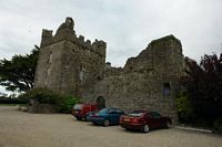
(1655.12) Ardcavan Church: An early church was founded by St Cavan in the seventh century AD, and it became the parish church of Ardcavan. Darinish Caemhain (the oak island of Caomháin), one of the islands inside the mouth of Wexford Harbour, was plundered by the Vikings in 819, together with nearby Begerin. The death of abbot Ciaran Mac Maol Dubh of Árd Caomháin is recorded in 890. A fragment of a wall is all that remains at the west edge of a raised oval graveyard.
(1655.13) Ballybrennan Castle: The Synnott family are thought to have been present in Wexford since the 13th century at least, and Ballybrennan in Forth barony is regarded as their principal seat in Wexford. A castle is depicted here on the 1656 Down Survey barony map. The castle was situated on a level, low-lying landscape, and the original south west corner of Wexford harbour is c. 200m to the north. Its walls are 1m thick and it survives to two storeys with false crenulations on the front. One narrow pointed window in the south wall may be an original feature but it is set in brick.
(1655.14) Begerin Church: This is an early ecclesiastical site within an oval raised graveyard defined by field banks and situated at the north east of what was the island of Begerin in the tidal north slob of Wexford Harbour, but since the reclamation work of the mid-19th century it is now part of the reclaimed north slob. The church was founded by Bishop Ibar, or Iobhar, in the fifth century. This saint was probably born in the Louth - Meath area and could have associations with many early Irish saints including St. Aba¡n of Adamstown. His death is thought to have occurred c. 504-10, and his feastday was on the 23rd of April. The monastery was plundered by Vikings in 819 together with nearby Ardcavan, but it continued into the 10th century at least.
(1655.15) The 1840 6 inch Ordnance Survey map of Wexford Harbour shows Big (Great) Island as two separate islands, a long narrow northern one and a wide squat southern one, joined by stone steps.
(1655.16) According to the Annals of Ulster, Dairinis, or Inis Beg, was plundered by the Norse in 819 along with neighbouring Begerin Island.
(1655.17) The Burrow graveyard was situated on the west side of the Rosslare sand-spit there is no visible evidence of an enclosure or of burial associated with St. Broagh’s church but archaeological testing here in 2006 recovered nine burials from the graveyard within a cottage where the south wall of the church was also identified
(1655.18) On this early map there are two Brest Islands, Little Brest to the north and Brest to the south.
(1655.19) The first mention of a fort on this peninsula was Boazios map of Ireland (1599), which indicates a fort - but not its precise location - in the vicinity of Rosslare. Speeds map of 1610 shows a structure on the peninsula. Around 1642 a substantial stone fort was erected near the top of the peninsula by the Catholic Confederate army. A substantial area was also acquired to enlarge the defences and provide military accommodation. When Cromwell arrived in Wexford in October 1649 he sent troops south to take Rosslare Fort. It is said that the Confederate soldiers quit the fort on the approach of Cromwell’s men without a shot being fired. With the fall of the fort Cromwell’s fleet sailed unhindered into Wexford. There is very little further military reference to the fort after the time of Cromwell.
(1655.20) Raven Fort: In 1641 a decision was taken in Wexford to declare for the Catholic confederacy. In anticipation of a siege, extensive work was carried out on all Wexford's defences, namely the Town Walls and Rosslare Fort. A fortification of some kind, known as Fort Margaret, was erected on the Raven Point, the northern arm of the Harbour entrance. It is not clear if it was ever completed though, as it did not seem to take part in any subsequent events.
(1655.21) Begerin is an early ecclesiastical site within an oval raised graveyard defined by field banks and situated at the NE angle of the island. Begerin is one of the most famous early Christian sites in Wexford, associated, in the 5th Century, with St Ibar, who established a monastery there. He is said to have named the island, which means 'small Ireland'. St Ibar died around 500AD but his monastery lasted for several centuries after his death, despite being ravaged by the Norse on several occasions during the ninth century. Three carved stone slabs, dating from the ninth or tenth centuries, were found at Begerin. Research on the artwork on these stones, (now in the county museum collection in Ferns) points to a strong influence from the Isle of Man, Cornwall and Scotland. It has been suggested that the monastery was closed in 1160. In 1171, the inhabitants of Wexford town imprisoned the Norman leader, Robert Fitzstephen on Begerin. Ten years later, the Anglo-Flemish family of Roche, to whom the island had been given after the Norman Conquest, presented it to the Benedictine monks of St Nicholas at Exeter. The Benedictines built a church on the island in the thirteenth century, some remains of which can still be seen. In 1400, the island passed to the Augustinian canons of Selskar Abbey in Wexford town, but there is no evidence that they established a church there. The memory of Ibar and his monastery continued to influence the Wexford area well into the seventeenth century and down to the present day.

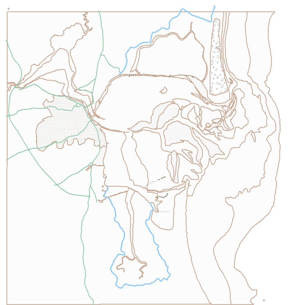
- 1
- 2
- 3
- 4
- 5
- 6
- 7

Loading